
Context
Indian National Centre for Ocean Information Services (INCOIS) and Indian Space Research Organisation (ISRO) will monitor and issue operational forecast alerts of rip currents.
What are Rip currents?
∙ Rip currents are strong, narrow, seaward flows of water that extend from close to the shoreline to outside of the surf zone.
∙ They are found on almost any beach with breaking waves and act as “rivers of the sea,” moving sand, marine organisms, and other material offshore.
∙ They are a common and potentially dangerous coastal phenomenon.
Cause of Rip currents
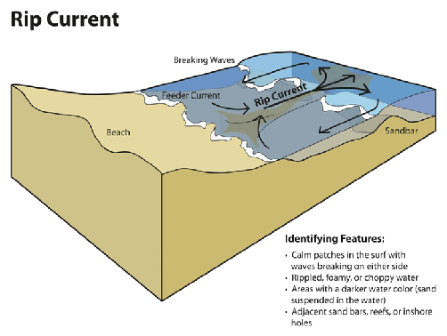
∙ These currents often form when waves break near the shoreline.
∙ Submerged structures such as sandbars, jetties, or reefs alter the flow of water, creating channels where currents can develop.
∙ As waves approach the shore, they may converge and create imbalances in water distribution, leading to the formation of channels through which excess water flows back to the ocean.
| Indian National Centre for Ocean Information Services (INCOIS)– INCOIS is an autonomous body under the Ministry of Earth Sciences (MoES) and is a unit of the Earth System Science Organisation (ESSO).– ESSO-INCOIS was established in 1999 under the Ministry of Earth Sciences (MoES) and is located in Hyderabad.– Indian Tsunami Early Warning Centre (ITEWC) is also housed in the INCOIS.– Mandate: To provide the ocean information and advisory services to society, industry, government agencies and scientific community through sustained ocean observations and systematic and focussed research. |